 The Herring River of Harwich has a rich history back to the Saquatucket our native Americans who inhabited this area. | |
Herring river has been managed by local industries for the past 350 years. Some of the activities of the people near the river influenced its past management. The history of the industries (cranberry industry, mills, ship building, and the fishery) and the land use surrounding the river and within its watershed will be discussed, and not just the 2.25 mile area that this study focuses on. By this examination, this study can serve as a future aid to any situation that may question what has happened on the river in the past.
The cranberry industry, since its beginning, has been by far the largest industry on the river. In 1816, a ship captain by the name of Henry Hall began growing wild cranberries in Dennis to feed his ship’s crew when at sea. Cranberries contain a high concentration of vitamin C and thus, helped prevent scurvy on long voyages.
In the northern section of the watershed, surrounding the tributary ponds of the river, the cranberry industry had many bogs which were irrigated with the pond water. For many years the cranberry growers used water from the ponds until they were drained below or level to their irrigation channels leading to their bogs. Because of the lack of adequate water level control, heavy rainfalls would flood their bogs and the cranberries would rot. This scenario occurred until 1852-1853, when Captain Alvin Cahoon observed that the surface elevation of Seymour Pond was 2 feet higher than the surface elevation of Hinckleys Pond. He thought if he could connect the two ponds by a channel or canal he could have water flow to provide irrigation to bogs along Hinckleys Pond. His two sons began to dig the channel without the aid of anyone else. The rest of the local residents felt that he was insane and laughed at the proposed channel calling it the "Cahoon Canal". However, when the canal was completed and water was flowing between the two ponds, the local residents changed their opinion of Cahoon’s Canal and a half dozen cranberry growers soon constructed bogs along Hinckleys Pond. During periods of low rainfall, water was provided to the bogs surrounding Hinckleys Pond and during heavy rainfall the majority of the water from Hinckleys Pond flowed into the River. Most of the growers that started bogs along shores of Hinckleys Pond also had bogs located around Seymours Pond. Since there were numerous bogs around the other tributary ponds, canals between them were soon dug. Besides Cyrus Cahoon, who had a bog along Hinckleys Pond in 1846, Zebina H. Small, who was one of the first men to experiment with the wild cranberries to develop an efficient, high yielding plant variety, set a plot at Grassy Pond.
 Cranberry bog along Hinkleys Pond Harwich. Historical Society | |
In the northern section along the banks of the River from the southwestern shore of Hinckleys Pond to the area known as "Great Swamp", is a wetland area that contains many old abandoned irrigation channels that are remnants of old cranberry bogs. These bogs, as well as the bogs extending south to the Main Street bridge were abandoned in the 1950’s because the dam and dike system used on the river for the irrigation of these bogs was destroyed. The bogs north of the "Great Swamp" area were believed to be owned by Dr. Butterfield, who employed a man named Ansel Drake to manage them. During a severe storm, which dumped numerous inches of water into the headwater ponds and the river raising the water levels significantly, Mr. Drake panicked and began releasing water from the diked areas to reduce the level of the water in the river and in Hinckleys Pond by removing the boards in the dikes. He made a critical mistake by removing the boards at Hinckleys Pond and in the northern section of the river first, there by creating a wall of water that sped downriver and destroyed the dike system all the way to the Main Street bridge. The dikes south of this area may also have been destroyed, but the bog owners could have rebuilt them. The owners of the bogs along the river north of Main Street decided not to rebuild their dikes and left these cranberry bogs fallow. This decision may have also been supported by a poor cranberry market which was saturated with cranberries which drove prices down and left many growers with tons of worthless berries.
The owners of the bogs south of "Great Swamp" to Route 6, prior to the time of the washout of the dikes, can be found on Map 5, titled Upper River Bogs. The bogs just south of "Great Swamp" on the western side of the river were believed to be owned by John E. Hall, with Paul Rose’s bogs just below them. On the adjacent bank of the river are other bogs that also belonged to Paul Rose. To the east of these bogs was a small bog owned by Robb Kimble, while to the south on the west side of the river, was another bog owned by Ruth Cordella. On the east side of the river, were the bogs of James Eldridge, Frank Barrows, and then Alton P. Hall, who’s bog is just north of the Route 6 bridge. This bog ownership information was taken from Map 5 that was found in a Herring River file provided by Tom Leach, Harbormaster and Director of Natural Resources, Town of Harwich. Mr. Leach was very helpful in gathering information about the northern river bogs, but was not completely certain of the authenticity of the information and stated that it should be verified with Link Thatcher, a local cranberry grower and resident of the Town of Harwich who is interested in the preservation and management of the river. Mr. Thatcher has lived in the area for many years and knows a great deal about the history of this area. It is hoped that all of the history relating to the river that Mr. Thatcher is aware of is documented to possibly aid in the preservation and management of the river.
 Baby alewives (fry) exit Long Pond by the tens-of-thousands seen here November 6, 1998. Tom Leach photo. | |
The names of the tributary ponds have changed numerous times over the past two hundred and fifty years. Seymour Pond received its name from John Seymour, who moved to the area of the pond. "Near it on the hill, many years since, lived an Englishman by the name of John Seymour, who was by occupation a tanner, and from whom the pond received its name." (History of Barnstable County, Massachusetts, Page: 826) This pond was also known locally as Bangs’ Pond, named after John D. Bangs, who lived here shortly after John Seymour. Hinckleys Pond, which was also known as Herring Pond and Pleasant Lake, received its name from Thomas Hinckley, a farmer who lived on the east side of the pond. Mill Pond received its name as a result of being near a windmill on the northern shore of the pond. The windmill was removed from the pond shortly after its roof blew off in the great gale of 1816. Long Pond was also known as "Great Long Pond" by the early settlers of the area. Cahoon Pond received its name from the Captain Alvin Cahoon family. Robbins Pond was named after Robert or James Robbins who also resided in the area.
In the area of Long Pond and Hinckleys Pond was a post office and the Old Colony railroad had a "flag" station where the train stopped. There is still evidence along the edge of Route 124 of the old track right-of-way that is the current location of the Cape Cod Rail Trail.
Although the area of this study from Hinckleys Pond through West Reservoir was dominated by cranberry bogs, there also were numerous mills and factories that harnessed the hydro-power of the river to operate their machinery. A cotton and wool factory, located on the river a short distance north of Route 6, was operated for some time before being converted into a carding mill for wool. Around the year 1825, the mill was converted into a grist mill by Richard Roger and was believed to operate until 1880.
The first grist mill built on the river was known as Hall’s Mill or "Middle Mill" and was located in the southern part of the old village of North Harwich. It received its name from the man who owned it, the first resident of this location (sometime before 1700), Samuel Hall, the eldest son of Gershom Hall, both of whom settled what is known as North Harwich. Sometime later, Ryder’s Mill was built in the same general location as Hall’s Mill. This mill was believed to be located not far north of Kelly’s Mill.
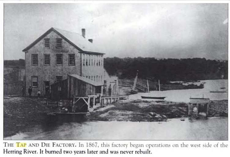 According to Brooks Museum this is the Benjamin F. Bee "Tap & Die Factory" located just north of main street today. But I think this may be the "NY Safety Valve Co." because you are looking down stream note small two masted sailing skiff below dam on the tidal side of the river and that company was located on the left bank.Could this dike actually be Main Street bridge? Photo courtesy Brooks Academy Museum | |
Kelley’s Mill, also known as "Lower Mill", which got its name from Patrick Kelly who owned and operated this mill shortly after 1762, was located on property believed to be just north of the Main Street bridge. Freedman Ryder Jr. took over the mill in the early 1850’s after Patrick Kelly died, and ran the mill for a few years until it was sold to Benjamin F. Bee, 1876. A tap and die factory was erected on the land by Benny Bee (as the locals called him) who created and manufactured the first blue jeans. The factory was also known to produce buttons at one time. In December of 1886 the factory burned down and many of the locals said that his neighbors were very jealous of Benny Bee and that they set the fire. After the fire the property was sold to the New York Safety Valve Company, who constructed a factory building on the east side of the river which produced safety sectional boilers. Benny Bee, who was the inventor and superintendent of the boiler factory, was also known as the inventor of the universal button fastener, the safety sectional boiler, and a cranberry picker.
Field’s Mill, another mill located on the river, although the exact location of which is uncertain, was believed to be near the location of the flume, approximately 250 to 350 feet upstream from the bridge on Great Western Road. This mill was a wood working mill that made fence posts and coffins.
In the 1930’s, a concrete block factory, owned by Cliff Wickstrom of Harwich Concrete Block, was built just south of the Main Street bridge on the east side of the River. After many years it was sold to Dan Speakman, who owned it until 1990 when it was torn down and the land was purchased by the Town of Harwich for preservation (conservation land).
South of Great Western Road, on the western side of the Herring River, between the river and Depot Street, stood a building used as a screening house. Here the harvested cranberries were brought from the surrounding bogs for screening by women who would remove the rotten berries to improve the quality of the harvest. The screen was developed by Vernon Johnson, who was a contractor for the bog owners, and known as the "Harwich Cranberry Screen". It was built for Marcus and Carl Urann, who at that time was the president of the United Cape Cod Cranberry Company. The original building, built in 1929, was added to in 1943 (the section closest to Depot Street) and in the late 1950’s, about ten years before it closed. It was owned and operated by the United Cape Cod Cranberry Company, which was run privately by the Urann brothers and later became Cranberry Canners Incorporated, which was owned by stockholders. In the early 1950’s this screening house handled 2,220,000 pounds of cranberries or 22,000 barrels in a season.
"Urann was the first person to can cranberries. He was sitting home one day with a pile of cranberries that could not be sold because the market was flooded. He said ‘This will never happen again. I’ll put them in jars first.’ This canning of cranberries happened in 1912. Urann experimented with it in his kitchen, canning and making whole sauce until it developed into a larger commercial project and he coined the name ‘Ocean Spray’." (Cranberry History, Interview with Dick Johnson)
In 1931 or 1932 Vernon Johnson diked the Herring River and made a cedar wood flume to control water flow into Bell’s Neck Bogs, Hall’s bogs (near the railroad track which is now the Cape Cod Rail Trail), Little Depot, and Big Depot Bogs. They used an old Cadillac engine to pump water from the river into the flume. They subsequently dammed the river, creating the West Reservoir (it has also been stated in another historical publication that the West Reservoir was constructed in 1880), which enabled flooding of the lower bogs when deemed necessary. Since the land was not cleared before it was flooded, cedar trees protruded through the ice in the winter and were cut for fire wood. This explains why the stumps in West Reservoir are all the same height. In the 1940’s, a bog was attempted to be built in the northeast corner of the reservoir, but the sand that was applied just sank into the underlying sediment. A 21 foot pipe was driven into this area and it didn’t hit a solid bottom, just silt or organic peat.
 Alosa Pseudoharengus is our common alewife. Click picture to learn more about its natural history. | |
The East Reservoir is a holding area for water that would flood Bell’s Neck Road if it wasn’t for a drainage culvert that links the two reservoirs. A small bog from many years ago was found in the southwest portion of the East Reservoir, but not much is known about it since the only remnants of it were only visible until the early 1950’s. The flume on the dam of East Reservoir was said to have contained a tidal gate used to keep saltwater from inundating the bog which washed out in the late 1980’s. In the bogs of this area, a variety of cranberry types were grown, since bogs were once owned by ship captains and each would plant his favorite berry in his section.
In the area just south of Great Western Road, on the east side of the river was a tract of land purchased by John Bell on December 16, 1668. There was a controversy regarding the limits of this land, which erupted during 1721. The owner of the property west of Wing’s line (refer to Map 4) and Samuel and John Berry of Harwich, both claimed ownership of the land. The boundary dispute over this tract of land, later named Bell’s Neck, was settled by John Paine of Eastham, Peter Thatcher, and Shubael Gorham of Yarmouth. John Bell was originally from Sandwich and may have been influenced to move here by John Wing and John Dillingham who lived in Sauquatuckett, an area southeast of Bell’s Neck, but also originated from Sandwich. Not much is known about the life or death of John Bell, although he resided for numerous years within the limits of the old town in a secluded place, except that the records of the Probate Court indicate his son-in-law, Samuel Berry of Harwich was granted letters of administration on October 3, 1700 and that John had died "some years since".
On the east bank of the river, near Bell’s Neck, is a small tributary, known as Coy’s Brook which was named after John Mecoy who owned the land in 1667. He also owned land along the river which has been referred to as the Hall neighborhood. In 1680 John Coy’s Island became Hall’s Island.
Along the banks of the Herring River from the Bell’s Neck area south to the area of Route 28, there was a large section of meadow from which In this both salt and fresh hay have been taken in large quantities for many years. This area has had many historic names such as Boreman’s Meadow, Berry’s Meadow, Gage’s Meadow, Hall’s Meadow, Pog’s Meadow, Paine’s Meadow, and Boggy Meadow. For further information on ownership and history about the properties surrounding the Herring River please refer to Paine’s History of Harwich, pages 46-351.
The village of West Harwich was settled in 1723, which was located in the southwestern part of the town on both sides of the Herring River. The west part of the west village was most thickly settled with residents engaged in fishing and other seafaring pursuits. The first person to settle within the village the town line west of the river, was William Chase who settled at the mouth of theRiver. He was soon followed by Samuel Smith, who erected a house near Amos Smiths residence. A bridge was built over the river near Job Chase’s house in 1804 and a public way from Dennis to the bridge was opened in 1808 by Job Chase, Sr., through his property. Vessels were built at this location near or at the mouth of the river from the beginning of the 19th century and did not end until 1848.
The Herring River marked the boundary between the Town of Yarmouth on the west side and Harwich on the east side from 1641 until 1692, when the Town of Dennis came into being. The river than marked the boundary between Dennis and Harwich.
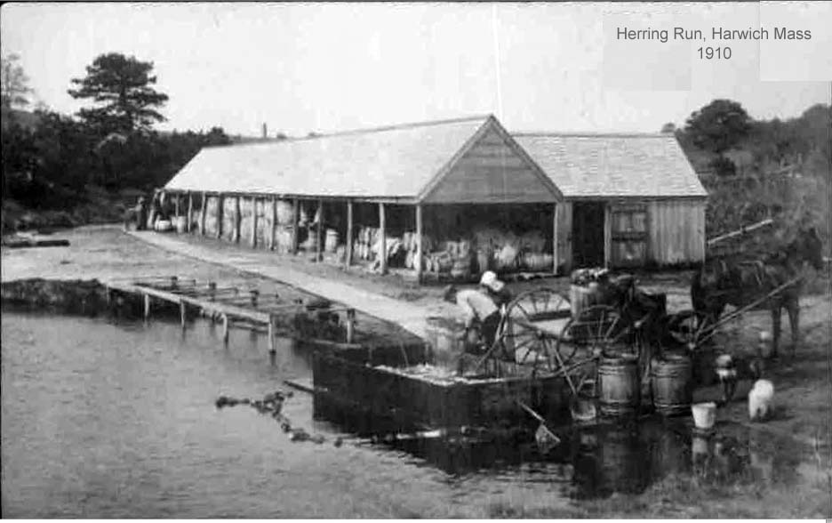
The alewife fishery appears to have been as plentiful in the past as it is at present. "Comparing recent with past years only two natural streams have maintained a high standard of production, Agawam River, Wareham, and Herring River, Harwich." (Report Upon the Alewife Fisheries of Massachusetts, page 29). Management and preservation of the river for the fishery have seemed to be a concern since the 1780’s. There have been numerous laws and regulations put in place since that time which have provided a successful fishery over the years. "The Herring River is one of the few streams which show a prosperous fishery as a result of proper care" (Report Upon the Alewife Fisheries of Massachusetts, page 98) The alewife fishery on the Herring River has been controlled by the Town of Harwich since 1787 when an act was setup to appointment a Herring Committee to provide provisions for passageways around obstructions, and a limitation of the fishing season. The town created special laws to regulate the herring fishery. There have been additional acts passed since 1787: one in 1813 for a provision to sell herring to the public; another in 1824 covering fishing restrictions on where fish could be caught; and another in 1844 (See Chart 1). The Town of Harwich adopted a 3 year lease on the herring fishery in the Herring River in 1884 and a five year lease in 1914 through 1919. In 1762 Hall’s Mill prevented the alewives from traveling further north up the river into the spawning ponds. The path upstream was soon corrected. "In 1764, it was estimated that upwards of 1,200 barrels of alewives were taken and sent to market from Harwich, with most of these fish coming from the Herring River." (History of Harwich, Page 347). "From the Herring River (in 1912) 1,500 barrels of herring were produced with a possible annual production for that year being 3,000 barrels. In an exceptionally good year as many as 3,700 barrels may be seined in the catching pool below the first fishway." (Report Upon the Alewife Fisheries of Massachusetts, page 98). This catching or seining pool was mostly removed by 1978. The average annual revenue to the Town of Harwich from the alewife fishery on the river from 1870-1879 was $349.00. In 1880-1889 it was $401.00, from 1890-1899 it was $558.00, from 1900-1909 it was $645.00, and from 1910-1919 it was $1,107.50. The fishery was one of the main businesses for the Town of Harwich for many years. "At Herring River, Harwich, twelve to fifteen women were engaged in the process of scaling the fish on May 11, 1920." (Report Upon the Alewife Fisheries of Massachusetts, page 26).
The Coy’s Brook was dug through "Bridge swamp" in 1842 by the Coy’s Brook Fishing Company. The brook was to be dug from the Herring River up through Andrews Pond, Cornelius Pond, Walkers Pond, and was to end in Long Pond which would have allowed the alewives to access three new ponds and would also have provide a different path, other than the Herring River, to Long Pond. However, the brook became obstructed with debris in 1855, when Obed Brooks, Jr. and Associates were allowed, by an act of the Legislature, to remove the debris near Hall’s Island and from Clark’s Pond and Flax Pond for the purpose of allowing the alewives a free passage to these ponds. "Formerly fisheries were also maintained on the tributaries, Coy Brook and White Pond Brook. As a result of careful town management the fishery has been maintained at a high level, through the constant watchfulness on the part of the local committee and the district deputy of the Division of Fisheries and Game in seeing that no obstructions have been permitted to exist on the stream during the spring run. Its future success depends upon the continued exercise of this care" (Report Upon the Alewife Fisheries of Massachusetts, page 98).
The Town of Harwich has been concerned about preservation and management of the river and the surrounding land for many years. In October of 1988, the Harwich Land Trust was formed to buy as many parcels of land along the river as they could to preserve and protect the river from pollution and development. A Report to Town of Harwich, Massachusetts Conservation Commission on Conservation Improvement Plan for Herring River Watershed Within Town of Harwich, Massachusetts, February 1974, by Dr. Paul Godfrey, Metcalf & Eddy, Inc. was a study conducted for the Town of Harwich concerning of the preservation and management of the area of the river and the alewife fishery. In 1984, limnological* data (water quality studies) was gathered on Hinckleys Pond and West Reservoir (The Reservoir) and presented in Baseline Water Quality Studies of Selected Lakes and Ponds in the Cape Cod Area, Volumes 1 & 2, Massachusetts Division of Water Pollution Control. This was done by the state under the Lakes and Ponds Grant Program. On December 22, 1994 a Report on Herring River Condition & Suggestions was purposed by Tom Leach (Natural Resources Director for the Town of Harwich). On February 2, 1995, a Herring Run Management Plan was also purposed by Tom Leach because of his concern for the preservation and ecology of the river. Most recently, A Diagnostic Study for the Preservation and Management of the Herring River, Harwich, Massachusetts, by Garrett M. Tunison, was completed in September, 1997. It is hoped that the Town of Harwich will continue to develop a plan to fully manage and protect the river from further development and pollution. To aid in this development, Chapter 10, RECOMMENDATIONS has been included to outline a program for the Town of Harwich over the next decade.